

Introduction
Drones have become ubiquitous in various industries, from photography and cinematography to agriculture and surveying. As the demand for accurate and reliable positioning of drones continues to rise, Real-Time Kinematic (RTK) technology has emerged as a key player in enhancing the precision and efficiency of drone navigation. In this article, we’ll explore how RTK technology works in the context of drones and its transformative impact on aerial applications.
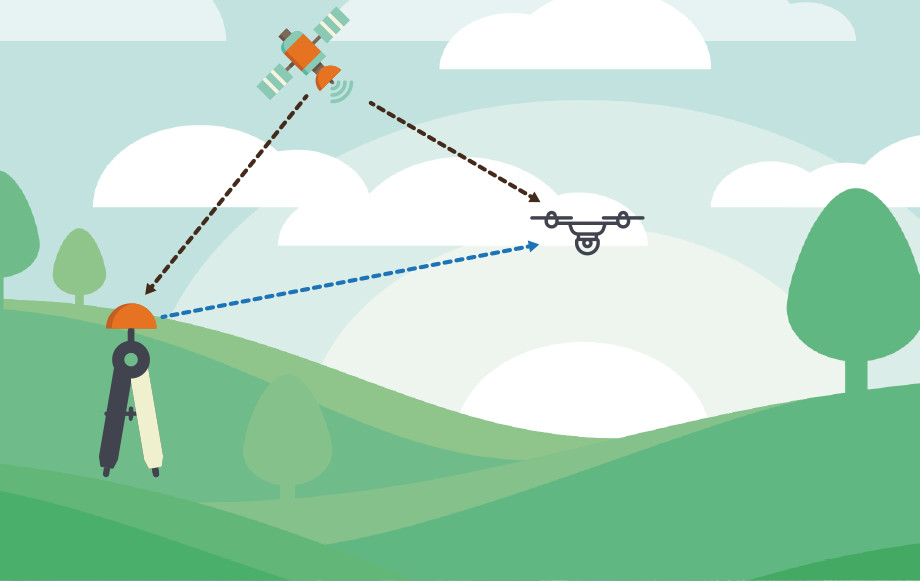
Understanding RTK in Drone Navigation:
- Enhanced Precision: RTK technology significantly improves the accuracy of drone positioning. While traditional GPS systems may provide meter-level accuracy, RTK-enabled drones can achieve centimeter-level precision. This level of accuracy is crucial for applications that require meticulous spatial awareness, such as mapping, surveying, and 3D modeling.
- Dual GPS Receivers: RTK-equipped drones are equipped with dual GPS receivers – one on the drone itself (rover) and another on a known, fixed location on the ground (base station). The base station precisely determines its coordinates and transmits correction data to the drone in real-time.
- Real-Time Corrections: The key to RTK’s success is the instantaneous correction data sent from the base station to the drone. This data compensates for errors introduced by factors like atmospheric conditions, satellite clock inaccuracies, and signal reflections.

(Image source: Dronelife.com)
Applications of RTK in Drone Technology:
- Surveying and Mapping: RTK-enabled drones are invaluable in surveying and mapping applications. Whether it’s creating detailed topographic maps or conducting land surveys, the centimeter-level accuracy provided by RTK ensures that the collected data is highly reliable.
- Agriculture: Precision agriculture benefits immensely from RTK technology. Drones equipped with RTK can precisely monitor crop health, optimize pesticide and fertilizer application, and create detailed field maps for improved farm management.
- Construction and Infrastructure Inspection: In the construction industry, RTK-enabled drones play a crucial role in tasks such as site monitoring, progress tracking, and infrastructure inspection. The high precision allows for accurate measurements and assessments of construction sites.
- Search and Rescue: RTK-equipped drones are used in search and rescue operations where precision is critical. The ability to precisely navigate and position the drone aids in locating missing persons or assessing disaster-stricken areas.
Conclusion:
Real-Time Kinematic technology has brought a new level of accuracy and reliability to drone navigation, unlocking a myriad of possibilities across diverse industries. As technology continues to advance, the integration of RTK in drones will likely become more widespread, further expanding the capabilities and applications of these aerial vehicles. The precision offered by RTK not only enhances the efficiency of drone operations but also opens the door to innovative solutions in fields where accuracy is paramount.
At Bee Aerial we can help you with highly skilled drone operators and the right equipment.
If you are interested in how the 3D Dolly Works in details, please have a look at the video below:
Get in touch!